Canyonlands National Park is a vast and stunning landscape located in southeastern Utah. The park is known for its rugged canyons, towering mesas, and otherworldly rock formations, which have been shaped over millions of years by the forces of geology. In this article, we will explore the geology of Canyonlands National Park and the processes that have created its unique landscape.
Formation of Canyonlands National Park
The geology of Canyonlands National Park dates back to the late Cretaceous period, approximately 80 million years ago. At this time, the area was covered by a shallow sea, which deposited layers of sediment that eventually formed into the rock layers we see today.
Over time, tectonic activity caused the land to uplift and create a plateau. The plateau was then cut into by the Colorado and Green Rivers, which formed the deep canyons and valleys that we see in the park today.
The layers of rock that make up the park’s landscape are arranged in a series of parallel layers or “strata,” which reveal the geological history of the area. These layers are composed of a variety of rock types, including sandstone, shale, and limestone.
Erosion and Weathering
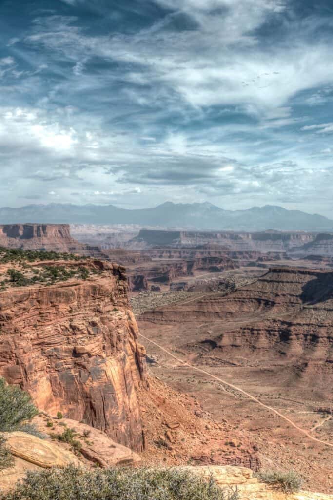
The formation of the canyons and valleys in Canyonlands National Park was largely a result of erosion and weathering. Over millions of years, the forces of wind and water have slowly eroded the layers of rock, creating the deep canyons and valleys that we see today.
One of the most prominent features of Canyonlands National Park is the White Rim, a layer of sandstone that forms a prominent bench along the cliffs of the canyons. The White Rim was formed by the slow erosion of the sandstone layers, which left a harder layer of rock that is more resistant to erosion.
Another prominent feature of the park is the Maze, a labyrinth of canyons and valleys that is difficult to navigate. The Maze was formed by the erosion of the softer rock layers, which were more easily eroded than the harder sandstone layers.
Folding and Faulting
The geology of Canyonlands National Park is also characterized by folding and faulting, which have created some of the park’s most dramatic landscapes.
Folding occurs when layers of rock are bent and folded due to tectonic activity. This is evident in the park’s Mesa Arch, which is perched on the edge of a steep cliff that has been folded and uplifted by tectonic forces.
Faulting occurs when tectonic forces cause the earth’s crust to break and shift, creating fractures or “faults” in the rock. One of the most prominent faults in the park is the Upheaval Dome, which is a circular depression that was likely formed by a meteorite impact. The Upheaval Dome is located along a fault line, and the impact likely caused the fault to rupture and create the circular depression.
Geologic Time Scale
The geologic time scale is a tool that geologists use to understand the history of the earth and the processes that have shaped its landscapes. The time scale is divided into various periods and epochs, each of which is characterized by a particular set of geological events.
The geologic time scale is particularly useful for understanding the formation of Canyonlands National Park, as the park’s layers of rock and the processes that have shaped them can be linked to specific periods in geological history.
Canyonlands National Park is a remarkable landscape that is a testament to the power and beauty of geology. The park’s towering canyons, mesas, and rock formations are the result of millions of years of erosion, folding, faulting, and other geological processes. For anyone interested in geology or the natural world, Canyonlands National Park is a
Related posts:
Canyonlands national park in southern Utah is well-known for its spectacular natural desert landscape shaped by the Colorado River and other mountain ranges. The park is also known for being the home of the Cedar City-Brian Head Tourism Development. ...
The Shafer Trail is a 19-mile dirt road that winds through the rugged landscape of Canyonlands National Park in Utah. This thrilling drive takes you along the canyon rim, through narrow switchbacks, and down a steep descent into the p...
Canyonlands National Park is located in southeastern Utah, United States. It covers an area of more than 337,000 acres and is home to some of the most incredible natural wonders in the country. One of the most popular activities in th...
Canyonlands National Park is a stunning natural wonder located in southeastern Utah. Spanning over 337,598 acres of red rock canyons, mesas, and spires, the park is a haven for outdoor enthusiasts and nature lovers. With so much to se...
Canyonlands National Park is located in southeastern Utah and is known for its unique landscape of canyons, mesas, and buttes. The park covers over 337,000 acres and is divided into four distinct districts: Island in the Sky, The Needles, T...
Canyonlands National Park is a breathtaking landscape located in southeastern Utah, USA. Covering over 337,598 acres, the park is divided into four distinct districts: Island in the Sky, The Needles, The Maze, and the Colorado and Gre...